-
×
 2027 A.T. Guide (PUR Bound)
1 × $21.21

Sale!



2027 A.T. Guide PDF Download
Original price was: $24.95.$21.21Current price is: $21.21.
The digital solution for The A.T. Guide gives you all the interactive options you would want from an app, while staying true to our printed book format. Use the PDF with our free ATG PDF Reader App for iPhone, any PDF reader for Android (we recommend a free Dropbox account), or on your desktop computer and print pages on demand directly from either.
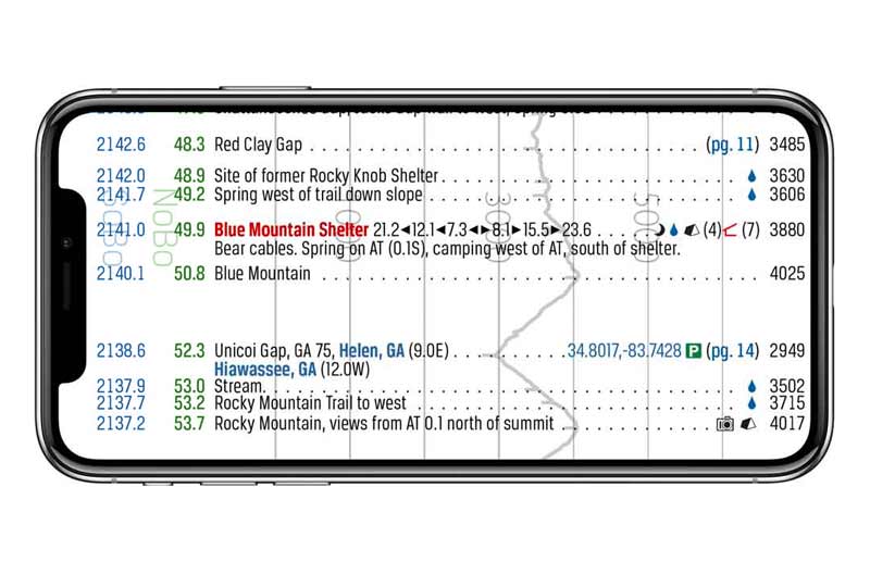
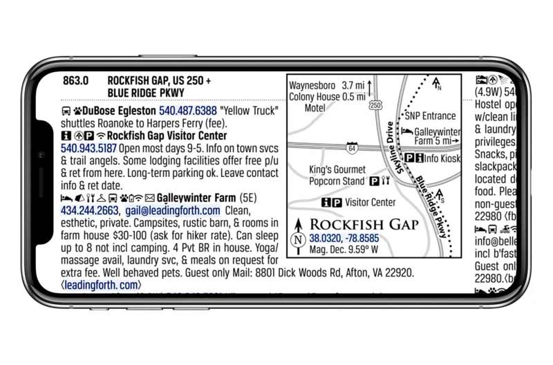
- Everything you need to plan and hike the Appalachian Trail: Town maps, waypoints, elevation profiles, mileage data, and essential trail information.
- Compatible with multiple devices: Use our official A.T. Guide PDF Reader App for iPhone. For Android, we recommend a free Dropbox account utilizing their built in PDF reader. Desktop users can open the PDF with any compatible reader.
- Print pages: Print from your desktop or wirelessly through our iPhone app.
- Interactive links: Tap websites, email addresses, GPS coordinates, phone numbers, and page references.
- Mileage tracking: Plan daily mileage and track your progress with our mileage log tool.
- Northbound & Southbound: Color-coded NoBo and SoBo mileages for easy reference.
- Personal notes: Add annotations to highlight important information.
- Offline access: View your downloaded PDF without Wi-Fi or cell service.
Since 2010, The A.T. Guide, also known as The AWOL Guide, has been a trusted resource for Appalachian Trail hikers. The interactive PDF contains the same information as the printed guide, with the added convenience of digital navigation and access across your devices.
Whether you're planning a thru-hike, section hike, or something in between, the PDF puts detailed trail data, elevation profiles, town maps, and service information at your fingertips, both at home and on the trail.On the Trail
- Mile-by-mile landmarks for both northbound and southbound hikers.
- Elevation profiles aligned with trail landmarks.
- Shelters, campsites, water sources, road crossings, summits, gaps, and other points of interest.
- Shelter listings with distances to surrounding shelters and information about water, tenting, privies, and food storage facilities.
Off the Trail
- 102 town and area maps for resupply and town logistics.
- Detailed listings for lodging, resupply, outfitters, shuttles, post offices, and other services.
- Services organized by trail access point and distance from the trail.
- Transportation options, parking information, and GPS coordinates at key access points.
The Advantages of the Interactive PDF
The PDF retains the familiar layout of the printed guide, with features that make it especially convenient for planning and navigating:
- Clickable links: Open websites, maps, GPS locations, phone numbers, and email addresses directly from the guide.
- Linked page references: Move between trail data and corresponding town services without scrolling through pages.
- Offline access: Keep the PDF on your device for use without cell service.
- Flexible viewing: Use the PDF on your phone, tablet, or computer with your preferred PDF reader.
- Personalize your copy: Highlight, bookmark, and annotate pages using your reader's available tools.
- Print what you need: Print individual pages or sections for your hike.
Use the PDF Your Way
Our free A.T. Guide PDF Reader app for iPhone and iPad provides a reading experience designed for The A.T. Guide. Simply log in with your account to access your purchased PDF.
Prefer another reader? Download the PDF from your account and open it in your favorite PDF app on Android, iPhone, Windows, Mac, or another compatible device.
Updated for the 2027 Hiking Season
Each edition represents months of research, updates, and coordination with trail-maintaining clubs, the Appalachian Trail Conservancy, local businesses, shuttle providers, and hikers. Trail relocations, service changes, regulations, and other updates are incorporated each year to keep the information as current and useful as possible.
The PDF includes 240 full-color pages, 102 town and area maps, and detailed trail information from Springer Mountain to Katahdin.
The same practical trail reference hikers have relied on for years, with the flexibility and convenience of an interactive PDF.
PDF Instructions
iPhone Instructions

- Download App from App Store
- Open the App and tap either "I have already purchased a PDF" or "I need to purchase PDF"
- Create an account or log into your existing A.T. Guide account
- If you have already purchased a PDF your PDF will load into your app and you are ready to go. If you need to purchase a PDF you will be directed through the checkout process. Once checkout is complete your PDF will be loaded into your app.
Here is our video series for how to use our A.T. Guide PDF Reader for iPhone. There are 12 very short videos. Tap the menu in the top right corner of the playlist to view the entire playlist and select the topic you would like to see.
Android Download Instructions
You can download The A.T. Guide PDF directly to your Android device and open it in your favorite PDF reader. We recommend Dropbox, which also lets you store your PDF for offline use.
-
Download the free Dropbox app and create an account. You don't need a paid subscription! Choose the free Basic plan.
-
Open your A.T. Guide order confirmation email and tap the PDF download link. Choose your browser if prompted.
-
Find the PDF in your device's Downloads folder.
-
Tap the three dots (⋮) beside the file, select Share, and choose Dropbox.
-
Open Dropbox and enjoy your Guide!
Prefer another PDF reader? No problem! Just open your downloaded PDF in whichever app works best for you.
Manual Download Instructions
Your PDF may be manually downloaded to your computer or mobile device in 2 easy steps:
Desktop Instructions:
- Access your order confirmation email or login to your account downloads, click the download link.
- Go to your downloads on your computer to access, and move your download to where you would like to store it and open it with the PDF reader of choice. For desktop use, we recommend Adobe Acrobat Reader for desktop.
Troubleshooting
Please update your iOS app to the latest version 1.0.8. This version fixes the login issue.
If you purchased the 2026 Book & PDF Combo and your PDF is showing a previous year, please make sure first that you are using the most up to date version of the app. If you still have a problem, contact us so we can correct your account.
Once we’ve made the correction, refresh your purchases in the app. If the wrong PDF still appears, tap the three dots (…) on the book cover and select “Re-download the Latest PDF Version.”
- Make sure you used the same user account with which you purchased your PDF. Some people unintentionally create multiple accounts. If you need assistance consolidating your purchase history to one account, please contact us.
- Refresh your purchase history, and activate your recent purchase. This is how:
-
- Go to your “SETTINGS” panel in your ATG PDF Reader App.
- Tap, “Past Purchases”.
- Tap the 🔄 on the top right side above your list of past purchases to refresh your list.
- Check the items in the list you would like to show in your app library. Unchecking items does not delete them permanently from your account. It simply hides them.
Email or call us and we will be happy to send you your correct username and send you a link to reset your password.
Because of the layout of the book, the highlighter can have trouble highlighting large areas of text, especially text that is in columns. The work around is to keep your highlights simple. If you can not highlight as much as you want in one highlight, use a few smaller highlights.
Please refer to the dropdown menu above on this page, “Android Download Instructions.” If you continue to have challenges, please reach out and we will be happy to assist you.
- Contact us and we will be happy to send you your correct username and send you a link to reset your password.
Your username is usually your email address. If your full email doesn’t work, try just the part before the @ symbol.
To reset your password:
- Visit My Account.
- Click “Lost your password?” and enter your username or email address.
- Check your email for a password reset link and follow the instructions.
Still having trouble? Check your spam folder. If you don’t receive the reset email or can’t remember your username, please contact us. We’ll help you get back into your account.
If you can’t find your confirmation email:
- Search your email (including spam) for “Your A.T. Guide order has been processed.” Your download link is included in that email.
- You can also access your purchases through your Download Management Console. Log in to view your past orders and download links.
Not seeing your purchases? You may be logged into a different account. Please contact us if you need help locating or combining accounts.
Never received your confirmation email? There may be a typo in the email address used at checkout. Contact us with your correct email address, and we’ll help correct your account information and resend your download link.
FAQ's
iPhone: The ATG PDF Reader App is compatible with iPhone 11 and above. Earlier iPhones may experience clipping.
Android: The ATG PDF Reader App is currently not available for Android devices.
Windows: The ATG PDF Reader App is currently not available for Windows devices.
If you have a phone that is not compatible with our app, you may still use the PDF on your desktop computer and in any PDF reader that will work on your device. We recommend the built in PDF reader for Dropbox.
Yes! We want hikers to have the most current A.T. information, so we offer returning PDF customers an automatic upgrade discount.
Simply log in using the same account you used for your previous purchase. Our system will recognize your purchase history and calculate your discount automatically.
- Minimum discount: 15% off for returning PDF customers.
- Prorated discount: Your discount increases based on how recently you purchased last year’s PDF.
- Maximum discount: 100% off if you purchased last year’s PDF within the past 30 days.
- Where to purchase: Upgrade through our website or mobile app. Your discount will appear automatically when you’re logged into the correct account.
Having trouble logging in? You can reset your password on our website. If you’ve forgotten which email address you used, or you’re not receiving the password reset email, please contact us. We’ll help you locate your account and correct any email address errors.
Please contact us and tell us about it. We review new prospects starting in September each year. A decision for inclusion is is based on value to the hiker and available space.
Each year, The A.T. Guide works closely with the Appalachian Trail Conservancy (ATC) to reconcile Trail mileage, including relocations, reroutes, and other changes.
Our collaboration with ATC has improved significantly in recent years, allowing us to compare data, resolve discrepancies, and work toward consistent mileage across both publications before going to print.
Occasionally, small differences may still occur due to late-season Trail changes or publication deadlines. When necessary, we provide corrections and updates in our digital PDF and on our website.
Our goal is simple: accurate, consistent Trail data that hikers can rely on, with the Guide available in plenty of time to plan their hikes.
You can download our free PDF reader app in the iOS app store. The download is free, the PDF is sold separately.
- iPhone App Store: https://apps.apple.com/us/app/a-t-guide/id1523722049
- Andorid Google Play Store: You may use your PDF on your mobile device with any third party PDF reader. We recommend utilizing a free Dropbox account with their built in PDF reader.
- Windows phone users You may use your PDF on your mobile device with any third party PDF reader. We recommend the built in PDF Reader with Dropbox. You only need a free account.
It’s very easy. Download the app and log in using your TheATGuide.com username and password and the app will pull your PDF purchase in, ready to use. We have made several short tutorial videos to help you maximize the features of the app.
Not at all! You can open The A.T. Guide PDF in any PDF reader you prefer.
Our free A.T. Guide PDF Reader is designed specifically for our publications, allowing us to offer a more tailored reading experience and develop features for our hikers.
However, you’re welcome to download your PDF and use your favorite reader instead. This is especially useful for Android and Windows users, or anyone who prefers the features of another PDF app.
The choice is yours. Use whichever reader works best for you!
No. The reader itself is a free download. You may purchase the PDF directly through the app or at TheATGuide.com.
You may also like…
Sale!

Original price was: $24.95.$21.21Current price is: $21.21.
Sale!
Original price was: $24.95.$21.21Current price is: $21.21.
Sale!


Original price was: $39.95.$36.21Current price is: $36.21.
